


Hello!
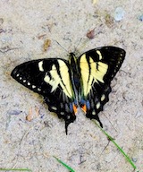
In the last year I got some butterflies from different localities in Peru. As I am having some difficulties in identifying them, especially the Lycaenidae, I ask you to help me. Since I have more than a hundred butterflies to identify, I put the photos in a cloud. You can find the link below.
I really hope some of them can be identified.
Thanks in advance and Happy New Year to you all.
https://ln5.sync.com/dl/1c1ac5360/2a2ry ... w-r7b7dcg7
Butterfly Identification Peru


Re: Butterfly Identification Peru
What is the meaning of -130/-715 on your labels.
Re: Butterfly Identification Peru
It means 13.0° South and 71.5° West. I round the coordinates of the locality in order to sort the butterflies geographically.


Re: Butterfly Identification Peru
No offense, even if those are temporary labels (e.g. papered specimens labels) the coordinates should be labeled in a standard format so it's readily obvious what it means.
I have old labels on specimens with "data" that meant something to the writer, but cannot be correlated to anything today. Similarly, I just read a book published in 1945 that gives locations such as "south of the Smith's farm" which today is useless; I suppose I could go find old county records but you get the idea. Then there's one location data "N**** Beach" and nobody today knows where it is, and I'm sure that is not on county property records.
I have old labels on specimens with "data" that meant something to the writer, but cannot be correlated to anything today. Similarly, I just read a book published in 1945 that gives locations such as "south of the Smith's farm" which today is useless; I suppose I could go find old county records but you get the idea. Then there's one location data "N**** Beach" and nobody today knows where it is, and I'm sure that is not on county property records.
Re: Butterfly Identification Peru
I totally agree with Chuck.
You have more than enough free space on your label so why not include coordinates in standard format so it will be useful in the future for who ever will end up with your specimen.
You have more than enough free space on your label so why not include coordinates in standard format so it will be useful in the future for who ever will end up with your specimen.
Re: Butterfly Identification Peru
You have weeks of ID work in front of you to ID all 200. Last year I purchased a number of lycaenidae from a dealer in Peru, and what I did was start with google. I googled "lycaenidae of Peru", then clicked on images. From there, find an image that's looks like your item, and visit that site and it might have both recto and verso photos for an accurate ID. For unique ones it's fairly quick, but as many are very similar, it can be difficult, and you may not be able to get an accurate ID on some. But either way, it will take a fair time investment on your part. I can not expect any off our members will tackle this for you, if you had posted just a few specimens, your chances would have been much better here.


Re: Butterfly Identification Peru
Use the BOA website - http://www.butterfliesofamerica.com/L/Lycaenidae.htm, Many will jump off the page for you - like look at Enos myrtea.
And I agree with all above - better label design would give you more than enough room to create meaningful labels. I've attached an example below - the "Blue dot" = 1cm.
John

And I agree with all above - better label design would give you more than enough room to create meaningful labels. I've attached an example below - the "Blue dot" = 1cm.
John
Re: Butterfly Identification Peru
My apologies for being further critical, I do so in the name of science.
Please do not round coordinates, or drop other data from labels. If a butterfly is important enough to be dead, and the time spent pinning and identifying, it deserves full data.
When I need to print labels which may have variation, I either copy/ paste identical series of cells, or leave a blank space. For example, I pre-print labels for places where I often research, and then fill in the day and month by hand.
Good luck with your identifications.
Re: Butterfly Identification Peru
You can also use iNaturalist.
For example, here are observations of Lycaenidae of Cusco region, Peru https://www.inaturalist.org/observation ... n_id=47923
Of course, you can always expand that to larger regions, since it's unlikely everything you have from Cusco has been posted on iNaturalist.
Another way is to "cheat" and post your butterfly observations on iNaturalist, and let others identify them for you.
Last edited by Chuck on Wed Jan 04, 2023 7:03 pm, edited 1 time in total.
Re: Butterfly Identification Peru
I hope you're not discouraged by the comments you're receiving, but see that this forum is full of passionate people who desire to see you succeed in the science/hobby and do it well.
I'd recommend you directly imbed, into this thread, the photos (dorsal/ventral) of the specimens causing you the most trouble, and demonstrate the work you've already undertaken to find an ID. Without doing that basic leg work you're asking IDers to invest a lot of time for you.
Now, I know nothing of South American species, but have built an expertise in African species over the past decade (especially those in E. DRC). If you were to post pictures of a random specimen from DRC, and it wasn't one of the common species (which you should be able to ID for yourself anyways), then it's likely to take me 5-10+ minutes (sometimes even longer) to come up with an ID. So, with 100 specimens to ID, that's asking someone to spend upwards of 8-16hrs IDing for you.
What I'm saying is that there may be folks who will be happy and able to help, but you need to make the task much easier for them. Narrow the ID down as much as you can, to genus or species group. Explain your thoughts on potential IDs. Don't flood IDers with many specimens at once (really, in my opinion, 5 at a time may be the upper limit). Try to group the specimens by genus. Share the specimen photos in a way that makes it easy to view both wing surfaces at once. If possible ensure those photos are hi-resolution and well lit & focused. Finally, accept that some specimens just can't be specifically ID'd (even by true experts).
Re: Butterfly Identification Peru
Thanks for all your comments.
I want to explain my lable design a bit more because you miss understood me. I do not really round the coordinates. For example for this specimen I do not have the detailed coordinates. I only have the locations like San Pedro, Cusco Region. What I do next is to look up the location on a map and see what coordinates it has. Then I "round" them in the way you can see on the labels. In this way I get something like a square of 0.1° X 0,1°. I do this because I want to group the specimens and then put them from the same square in the same drawer. So I can order the specimens like a distribution map in my drawers and in this way I can identify geographical differences. I can also visualise the distribution area of a species. So, the -130/-715 should not really be seen as coordinates but as a identification number for the square the specimen came from. I hope you understand because it is rather complicated to explain it in english.
Also I do not really expect to identify all of them. The reason I put them all together in the cloud is, that I hope some of you recognise a certain species by looking at it. I really do not expect that somebody waste all his time to identify 100 butterflies for me. Every single butterfly that gets an ID is a little succsess and if no one can be identified it is also ok because I have the specimen and the data for it.
I hope you understand me since my english is not really the best.
Create an account or sign in to join the discussion
You need to be a member in order to post a reply
Create an account
Not a member? register to join our community
Members can start their own topics & subscribe to topics
It’s free and only takes a minute